Riverside County Supervisorial District Boundaries
The County of Riverside supervisorial district boundaries are geographically redrawn every 10 years in line with the county's population changes as reported by the U.S. Census, most recently conducted in 2020.
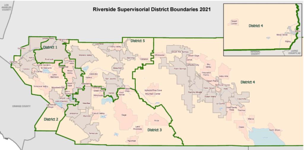
Following several weeks of public hearings and reviewing 38 versions of district maps, the Riverside County Board of Supervisors adopted new lines for the elected supervisors’ districts on Dec. 14, 2021.
Image
Community Feedback Received
Hours of public comment were heard during five public hearings, along with numerous written comments providing feedback on the redistricting process and draft maps. Revisions were made to draft maps based on input provided by community members.
The previous time the county went through a redistricting process was in 2011. To view the 2011 website, click here.
Online Feedback
Community members submitted feedback online, including providing suggested district lines, to help inform the County of Riverside in creating the new districts. The online feedback tool that was used to collect input was here. The deadline to submit draft maps was Nov. 1, 2021. To see a listing of all community responses received here.
Residents also provided comments via email at [email protected] or attended public hearings.
.
View Maps and Public Meeting Archives
Frequently Asked Questions
What is redistricting?
In accordance with the California Election Code Section 21500, following each decennial federal census, and using that census as a basis, the Riverside County Board of Supervisors adjusts the boundaries of any or all of the county supervisorial districts so that the districts shall be as nearly equal in population, and comply with applicable provisions of Section 1973 of Title 42 of the United States Code, as amended.
Are city, state and congressional districts part of the county's redistricting efforts?
No. Cities with wards or districts, as well as state and federal legislatures conduct their own redistricting efforts within their level of government. The County of Riverside is charged with only redistricting it's own jurisdictional lines, which are the five supervisorial districts.
When does redistricting occur?
It occurs every 10 years after each decennial U.S. Census. The most recent Census was completed in 2020 and the results were released in mid-August 2021.
The last time the county went through a redistricting process was in 2011. To view the 2011 website, click here.
When will the new district boundaries take effect?
The new districts were adopted on Dec. 14, 2021 and become effective as new elections are held.
The new 2021 district boundaries will go into effect for districts 2, 4 and 5 in January 2023. Supervisors will be elected within these new boundaries during the 2022 elections.
For districts 1 and 3, the new boundaries become effective in January 2025, following the 2024 elections.
Until that time, supervisors represent the districts across the 2011 boundaries they were elected in.
What is the effect of redistricting?
The 2020 Census data for Riverside County has been published and population shifts show an an unequal representation within the county’s 2011 supervisorial districts. Redistricting involves the adjustment of boundaries to maintain a substantially equal population between districts.
What factors are considered for drawing new boundaries?
The following are criteria that are factored in establishing new district lines:
- Equal population
- Federal and state law, including the Voting Rights Act
- Geographic continuity
- Preserve communities of interest
- Respect geographic integrity
- Boundaries shall be easily identified by residents
- Geographic compactness
To read more, click here.
What are the supervisorial districts for the County of Riverside?
Who decides district boundaries?
The County Board of Supervisors.
The board shall hold at least four public hearings before adopting the final map.
What is the 2021 Advisory Redistricting Commission?
-
The Advisory Redistricting Commission 2021 is comprised of the County Planning Commission and is tasked with constructing at least one redistricting proposal for the Riverside County Board of Supervisors to consider.
Advisory Redistricting Commission meetings are held during Planning Commission meetings. The Advisory Redistricting Commission does not have the authority to redistrict the county supervisorial districts, only the Board of Supervisors has that power.
Riverside County Planning Commissioners:
- Carol Bruce Shaffer, First District
- David Leonard, Second District
- Gary Thornhill, Third District
- Bill Sanchez, Fourth District
- Eric Kroencke, Fifth District
The Executive Office Technical Committee will present recommendations to the Advisory Redistricting Commission.
The Executive Office Technical Committee 2021 is composed of the following individuals:
- Rania Odenbaugh, Deputy County Executive Officer, Co-Chair
- Jeff Greene, Chief of Staff, 1st District
- Philip Paule, Chief of Staff, 2nd District
- Michelle DeArmond, Chief of Staff, 3rd District
- Steven Hernandez, Chief of Staff, 4th District
- Boomer Shannon, Chief of Staff, 5th District
- Charissa Leach, Director of TLMA/Planning
- Jim Smith, Chief Information Officer
- Tom Mullen, Chief Data Officer of RCIT
- Ronak Patel, Deputy County Counsel
- Rebecca Spencer, Registrar of Voters
- Brooke Federico, Public Information Officer
What is the timetable for redistricting?
The U.S. Census Bureau released redistricting data mid-August 2021. The Riverside County Board of Supervisors must adopt a redistricting plan before December 15, 2021.
The Census data for Riverside County shows population shifts that result in an unequal representation within the County’s supervisorial districts. Redistricting involves the adjustment of boundaries that may be necessary to maintain a substantially equal population between districts.
How can I see maps of the population and proposed new district boundaries?
Click here to see draft redistricting maps with citizen voting age population (CVAP) data.
You can also see a map of the 2020 Census data within the current supervisorial district boundaries. The map shows 2020 populations for each district and compares that figure with the target population of each district of approximately 483,000 residents.
How can I submit feedback on the district boundaries?
Community members submitted feedback online, including suggested district lines, to help inform Riverside County in creating the new districts.
See a listing of all online community responses received here.
Residents can also email [email protected] or attend a community hearing during the Advisory Redistricting Commission meetings.
How can I see a presentation with more information?
To watch a narrated power point presentation, play the video below.
Residents were also invited to participate in local community advisory council (CAC) and municipal advisory council (MAC) meetings held throughout Riverside County.
Click here to to see the list of redistricting presentations at local CAC and MAC meetings.